Two Sprint WREs: Finland and Norway

Orienteering

Note (7 Oct 2017): title corrected (Sweden -> Norway)

As I start my composition study at the University of Gothenburg, I joined two sprint World Ranking Events within a week.

The first one (17 September 2017) was near Helsinki in a neighbourhood called Kannelmäki (Gamlas), with the qualifications in the morning and the finals in the afternoon. (On a minor note, they didn’t print the course description on the map)

20170917am Finnish SM-Sprint Piian Puisto route.jpg

I was still recovering from having caught a cold earlier but my running-shape was still great. Still, I was obviously not fast enough and had to compete in the B2 final.

20170917pm Finnish SM-Sprint Kannelmaki route.jpg

The event was fun with a number of route choice traps. Also, it seemed like a journey back in time using EMIT cards (Hong Kong having switched to SPORTident a few years ago). If there was one thing to complain, however, it would be that the units owned by Helsingin Suunnistajat had no indicator lights at all (except the clear unit)!

21741308_10155710257510879_1442925615882433775_o.jpg


The second race (22 September 2017) was in Orkanger near Trondheim. This became the first time I went to Trondheim, as well as the first time I competed in Norway. Also, this was the first time I used the EMIT-tag touch-free technology (the other major touch-free system being SI-AIR+).

Orkanger 20170922 route.jpg

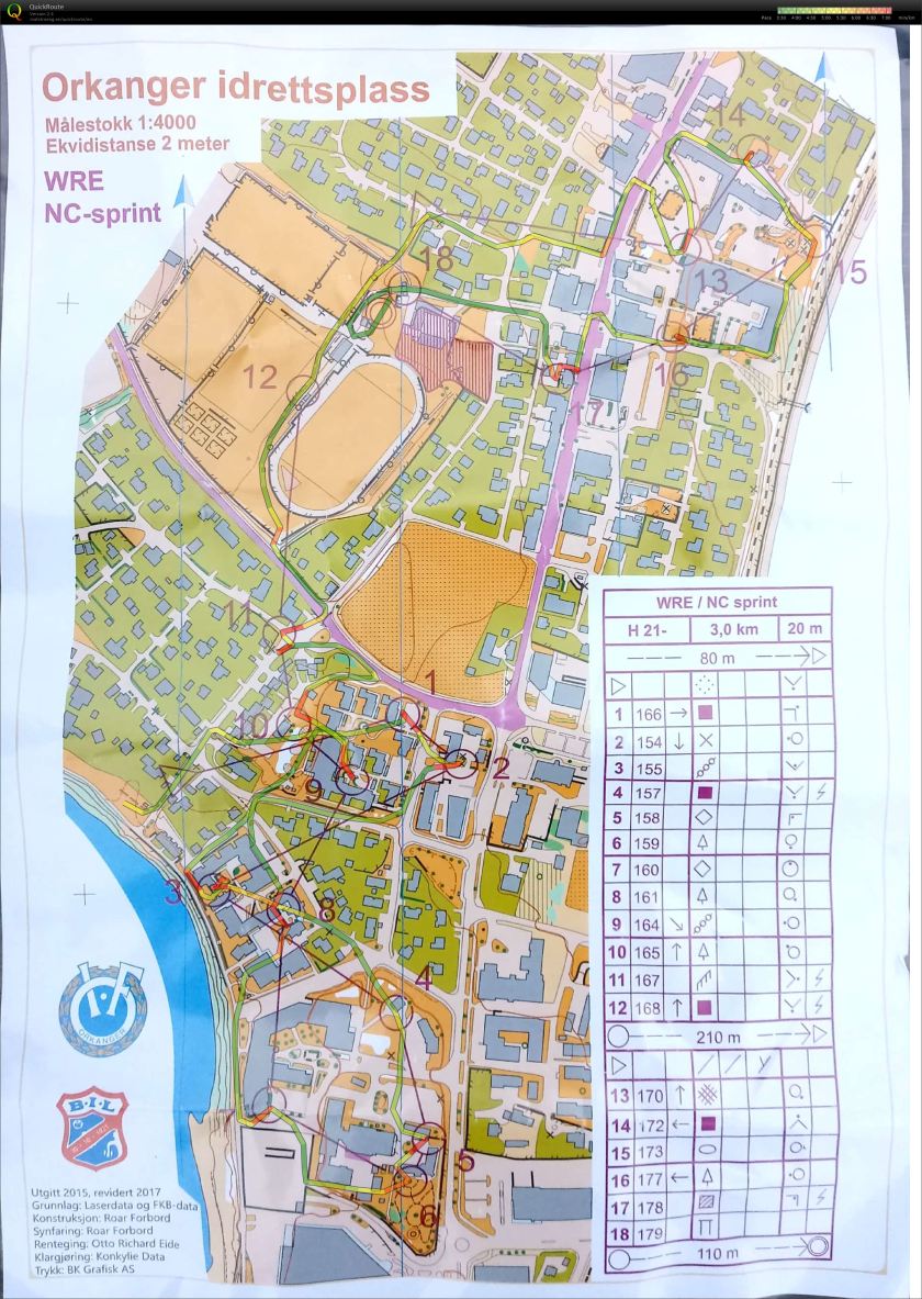
Too much hesitation on route choices!

21688405_10155724849070879_6421733081161379737_o.jpg

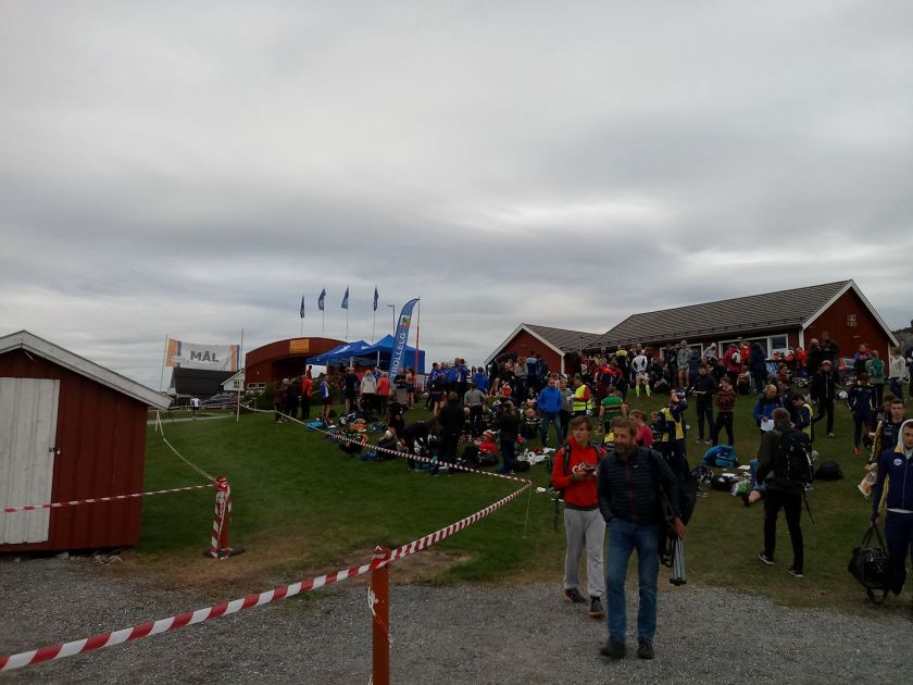
Despite the cloud cover, it still feels pretty warm in the late afternoon.

Being the only Asian guy in both events was, needless to say, interesting!

Midland Strategy, The Container Terminal, and Land Supply

Urban planning

The CBD3 (Third Central Business District) plan of the government, which proposes a huge artificial island at Kau Yi Chau approximately halfway between Hong Kong Island and Lantau, is probably rooted deep in the public consciousness by now. While it enjoys the strategic location in between Central, Kowloon and the airport and has the potential to spawn new infrastructure (as the proposed “Strategic Studies on Railways and Major Roads beyond 2030” may show), it might not be the best place to construct a new CBD after all.

Being of considerable distance from most major population centres (let alone major labour sources), the potential for the proposed artificial island to develop and prosper is in doubt. The City of Victoria took over a century under the tutelage of the colonial bureaucrats and taipans to come into prominence as one of the world’s major financial centres, and the East Kowloon CBD has all the industrial buildings and infrastructure for it to make a considerable jumpstart (not to mention being in the district with the densest population in all of Hong Kong), but CBD3 has none of these qualities. What’s more, all the transport infrastructure has to be developed anew, and we’re talking about transporting hundreds of thousands of passengers in an hour.

Now consider the Tsuen Wan area, which consists of Tsuen Wan and Kwai Tsing Districts. There’s already many people and businesses there—it’s a city of 800,000. So, why not move the Container Terminal to the sea and build the CBD3 there?

Let’s call the area Midland. In fact, I like to use Midland to describe all of the Tsuen Wan area from Tai Mo Shan to Lai Chi Kok Bay, from Tsing Lung Tau to Shing Mun (again, that’s Tsuen Wan and Kwai Tsing Districts combined—did anyone forget that the latter is a “breakaway” district of the former?) It’s really the geographic centre of Hong Kong.

midland CBD location.png

With the majority of the population in the New Territories, the Midland Strategy will save commuting times for a lot of people.

midland CBD spatial concept.png

We already have four railway stations which we can put into good use. Plus, we will get the opportunity to develop a whole new CBD on principles of sustainable development in the footsteps of Kai Tak.

(I actually submitted the plan right before the deadline of the HK2030+ consultation—not sure if they received it?)

Perhaps I’m not alone in proposing to move the Container Terminal. Our HK Foundation proposed that as well, without going into the planning details. (Article in Chinese)

Or build a podium over the Container Terminal directly like this article proposes? (Article also in Chinese) Either way, the Midland CBD is way sounder than a CBD on some artificial island at the middle of the sea.

Probably the orienteering event with the smallest area in the world 可能係世界上範圍最細嘅定向活動

MetOC, Orienteering, Sport

With the World Orienteering Day coming on 24 May this year, the Metropolitan Orienteering Club (MetOC) is going to organise (or more accurately re-enact) what is probably the orienteering event with the smallest area in the world in Kowloon Park.

How small is it? Well, to illustrate, I shall only have to use an excerpt from my SI Piece (that is, a music piece for SPORTident units) and a video of the premiere:

都會定向會將於世界定向日 (係五月廿四號、五月廿四號、五月廿四號呀,好重要所以要講三次) 喺九龍公園舉辦「可能係全世界範圍最細嘅定向活動」! 咁,究竟有幾細? 請睇以下小弟為定向打卡器而作嘅樂曲「譜」同埋首演錄影嘞:

SI Piece 1.png

Besides this, there is also a “slightly more normal” orienteering course — learn more at MetOC’s Facebook Page!

其實除咗呢個之外,重有個「正常少少」嘅定向嘅,想知多啲,請去MetOC嘅Facebook專頁睇下啦!

定向(最)基本功: Stop, Set Map, Select (停、正置地圖、選擇前進方向)

Orienteering, Orienteering coaching 定向教學, Orienteering Level 1

由今日開始我會喺度打一堆定向相關教學。因為諗住係淺白教學,用中文 (粵語) 打。

我敢講,做咗Stop, Set Map, Select之後,超過一半嘅錯誤 (mistakes) 都會消失。

即係點?

首先: 停喺度 (夠進階嘅,又或者想訓練得勁啲嘅,可以原地踏步)

跟住就係戲肉: Set map (正置地圖)

set map.png即係要將地圖同實地對正咁解。如圖,地圖上小徑方向同實際小徑對準,池塘喺小徑右邊。記得對埋前後左右地形邊邊高,邊邊低呀 (睇等高線 — 唔識嘅話遲下再教)!

最後: 你要行邊邊? 睇你條紫色線 (賽程,course) 指向邊啦,記得諗好哂去下一個control (checkpoint,控制點) 先好行呀。

其實stop, set map, select唔止定向有用呀,平時出街唔識路都有用架,開住Google Map問路記得set咗map先好行呀! 唔好做路痴係咁盪失路啦!

(註: 以我所知外國教練好少咁樣一套教嘅,不過相傳 (聲明,只係相傳,小弟未能證實) 係由瑞典黎香港支援定向發展多年嘅Perola Olsson推廣stop, set map, select嘅全套教法嘅,所以香港嘅教練通常都會使用呢個教法。)

Stop, set map, select is the most basic technique in orienteering and can probably prevent over half of the mistakes in a race. Stop really means to stop, set map means to rotate and align the map to match the real world features as seen by the runner (e.g. in the above picture, note the direction of the path and the relative position of the pond; you should also note the terrain around you, shown by the contours on the map), and finally select the correct path to the next control.

It’s not just useful in orienteering — it’s useful when you’re on the street with Google Map’s help too!

The teaching of the stop, set map, select technique as a package was said to be championed by Perola Olsson, a Swede who helped a lot in the development of orienteering in Hong Kong. Coaches in Hong Kong thus teach the basic technique in this manner, emphasizing its importance in the orienteering process.

ISOM migration – v2000 to v2017

Maps, Orienteering, Sport

The biggest news in the orienteering world now is easily the official sanctioning of the newest successor to the International Specification for Orienteering Maps. ISOM 2017 will come into force on 1 May 2017, less than 3 weeks later; the transition period will end on 1 January 2018, at which point all forest (middle/long distance) events must use the new standard.

Although there are eight months left before you’ll be required to adopt the new standard, I strongly recommend you to make the transition from ISOM 2000 to ISOM 2017 as soon as possible – especially if you don’t have events to hold for the rest of April – by converting your maps to the newest symbol sets. OpenOrienteering Mapper has not updated its symbol sets yet; OCAD has released an update which is also compatible with OOM (use the zip package for OCAD11).

Of note, the ISOM 2017 document is licensed under CC-BY-ND-4.0, probably the first IOF map specification to be released under any Creative Commons license.

A crude sum-up of the biggest symbol changes (very crude so don’t punch me for inaccuracies):

ISOM 2017 vs ISOM 2000

Okay so you’ve decided to make the “small” step to convert your symbols (to accomplish the “great” step for orienteering) – you’ll soon find out the hard part being that the bulk of the symbols have their numbers changed! No worries – I’ve made the following correspondence guide below to help you. The ISOM 2000 set on the left is the default from OOM while the ISOM 2017 set is from the OCAD update.

ISOM2000to2017 p1ISOM2000to2017 p2ISOM2000to2017 p3ISOM2000to2017 p4ISOM2000to2017 p5ISOM2000to2017 p6

Notes:
1. The discrepancies in decimal digits – being variants of the same symbol – are not significant and simply reflects differences in symbol handling between OOM and OCAD
2. Ignore the reversed directions of the cliffs and earth banks – again it stems from differences between OOM and OCAD
3. 521 Building – Black 65% is recommended for large buildings in urban areas. For small buildings or buildings in non-urban areas, the original black 100% can be used
4. 532 Grave – I wrote “custom symbol in Hong Kong” since it has been used with such frequency in Hong Kong, I speculate that the Orienteering Association might just decide to keep this as a special local usage. It is important to note that this symbol is gone from ISOM 2017 (from the 2015 draft onwards).

Last but not least, remember to factor in the transition when you coach orienteering – remind your students/cadets how the symbols will change in less than a year’s time!

Release of the ISSOM passability placard for public use

Maps, Orienteering

Today I am releasing the ISSOM passability placard, which adorns my sprint orienteering maps since 2015, for public use under the CC-BY-SA 4.0 license.

The license means, in short, that you are free to use the placard in any of your works as long as you attribute it to me (there’s an attribution in the files which you should keep) and use the same license to release the placard.

The placard describes which features are allowed to be crossed and which are not. It helps beginners identify passable and impassable features. Symbols are at 1:4000 scale.

ISSOM passability placard (600dpi)

Railway provision in Hong Kong – the geographical disparity

Urban planning

I’m taking three transport electives this semester and find it interesting to think about transport problems once a while (actually I’ve almost always been doing this). When it comes to essay topic – eureka! This is it – or maybe the statistical base for some bigger topic.

Yes, the geographical disparity of railway provision in Hong Kong – if you’re resident in the New Territories chances are that long commutes are an indivisible part of your daily routine, whether on a sardine-packed train or a bus stuck in the traffic. And as we Hongkongers all know but won’t always readily admit – the New Territories are inferior in terms of economic opportunities, transport infrastructure, … you name it.

Here is an analysis of railway provision across the 18 districts of Hong Kong, done on the basis of the planned 2031 railway network (search for “Railway Development Strategy 2014”) and the projected population by then. In the table below there are figures for the number of stations, internal segments and external segments (a segment being a section of the network between two stations) per 100000 people in each district. Here “people” is calculated by the average of residents and jobs (I have to take both into account to make things fair, but if I simply added them up I’ll double-count). Without further ado, the table: (click to access the pdf file)

mtr-density

The number of stations per 100000 people, visualised: (the deeper colour the higher share)

Main points:

  1. The traditional CBD districts (C&W, Wanchai, YTM) have a higher share than most districts
  2. Southern and Shatin have an exceptionally high share of stations for their population size; this is due to Ma On Shan Line and South Island Line which were built as medium-sized systems
  3. Islands District also has a higher share than many (Tung Chung is actually planned to house 250000 people and will have three stations, although here the population is forecast directly by overall population growth in Hong Kong; I’ve already excluded Airport and AsiaWorld Expo from the station count)
  4. Given Kwun Tong’s role as the second CBD, the share is disappointing (the upcoming Kai Tak EFTS will help things a bit, but no high hopes on that); not very surprising if you’ve seen the rush hour crowds at Kwun Tong Station by yourself?
  5. Those with the least share are all in the north and northwest; perhaps not surprisingly Tuen Mun has the least share? (Light Rail is not counted but it replaced the internal bus network wholesale at its inauguration, so fair enough)

Indeed, if you searched for the railway map of Hong Kong you’ll realise that the network by 2031 will still very much be a radial one, the only real cross-country link being the Northern Link straddling the borderlands. Tuen Mun will be having a new tunnel to Lantau in the near future but it’ll probably still be the “Land’s End” for most Hongkongers for decades to come.

Maybe it’d be great if the planners changed their mindset already and aim the New Towns at being full-fledged cities more or less on par with Kowloon or Victoria, instead of being “second-class bedroom communities”?

Introducing the Orienteering Starter Pack

Orienteering, Uncategorized

Two days after I completed my first HK100 race, I am officially introducing the Orienteering Starter Pack.

It’s a long time idea which aims at allowing the starter to obtain a compass, whistle, and the means to acquire basic orienteering skills, all in one box easily acquirable, so that more people can be introduced to orienteering.

You can order your Starter Pack here:
https://docs.google.com/forms/d/1cIDhemdkAKbWqHZjRohDkda7KQzDXfaOyMk-EDjjSTM/edit

ISSOM aid – Passable/Do not pass

Uncategorized

image

The above item appeared in the June 2016 issue of Sportsoho, a sport magazine in Hong Kong. Here I will not recall the circumstances behind this appearance, as I consider this case-closed (fellow orienteers will know; I have no grievances on this issue and I shall not discuss that again). However, I find it highly opportunate to explain how this item came into being.

Experienced orienteers will certainly get what information it reveals. (For the uninitiated: it shows which features you are allowed or not allowed to pass through, under the ISSOM rules, the rules that are in force in a sprint orienteering race. A sprint orienteering race is one that is usually held in cities and parks, that uses a 1:4000 or 1:5000 map, in contrast to races held in forests. By “not allowed” it means you get disqualified upon caught trespassing.)

I am not sure if there are any precedents in Hong Kong or elsewhere, although in Norway they have a “fair play” box on the map wherein impassable features are listed with crosses (search for maps from the famous Bergen Sprint Camp).

The impetus behind its creation was a need to differentiate the “Passable”/”Do no pass” symbols quickly during a sprint race. Characteristics to be distinguished include line width and colour. It can also render help to a competitor new to this orienteering format, or have difficulties differentiating these symbols. Although not initially the intention, a local orienteering coach has noted that it is currently used by coaches to teach ISSOM passability rules to children.

I designed this for a sprint map of Tseung Kwan O in April last year, and has included this in every sprint map I published since (most are for MetOC but some are for HKCEO and the aforementioned TKO map was for HKOC).

Ironically, I was disqualified in an important race last year because I trespassed an olive-yellow zone without even knowing. This has been a major blow to my motivation to compete ever since (combined with other factors such as coursework pressure). Perhaps prolonged orienteering fervour is not psychologically healthy and needs a rest.

The greatest thing I have learned from the ISSOM aid, however, is that you don’t often realize your full influence/contribution; keep on creating/innovating and you’ll be recognized and rewarded some day in the future.

Orchestral Piece for a New Era

Music, Music works

Now with one year past I think I dare to post this here. It was a remarkable experience which I don’t even know if there will be a repeat or anything that comes close. Again I could only say wherever my encounters take me.

The minimalism is explicit; this has been pointed out by my friends (search for the finale of Takashi Yoshimatsu’s Symphony No. 2; there’s no more definite inspiration than this).

It’s now very clear that, even if I am to carry on composing, I’m not giving up tonality any time soon.